 The area of the Society’s concerns is described by the ancient boundaries of the Parish of Mortlake with East Sheen. It is located on the south bank of the Thames and stretches up the slope of the hill and into Richmond Park. It runs from the centre of White Hart Lane on the east, follows Beverley Brook into Richmond Park and turns west to pass on the south side of Lower Pen Pond. It extends as far west as Kidney Wood where it turns north, skirting Sheen Common and continuing to Tangier Road over to Clifford Avenue and along Mortlake Road to Townmead and the River.
For over 800 years courtiers, artists and statesmen have built their palaces and stately homes, planted trees and beautiful gardens in this Parish. Their achievements have given lasting character to the area contributing in many areas to its look and feel of the country.
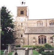
The River has always been of vital importance providing transportation, communication and fishing for the residents of Mortlake and East Sheen. It was on the River in 1348 that the first church, Saint Mary the Virgin, was built. Re-sited in 1543 its tower is the oldest building in the Parish. It was also on the River that the famous Mortlake Tapestry, the area’s most illustrious industry was located in 1619. It was established under the patronage of James I and continued in existence producing exquisite tapestries and other fine goods until it finally closed in 1703. From the 17th century onwards the produce of many market gardens was transported by barge down-river to London. View panorama of Mortlake Reach.
With the building of the Hammersmith Bridge in 1827 (today’s bridge is a rebuild by Sir Joseph Bazalgette dated 1887) and the coming of the railway in 1846 the character of Mortlake and East Sheen changed to that of a suburb of London. Today it is a justly desirable area in which to live where the parks, commons and open spaces are the gifts of the past and the responsibility of the present to preserve for the future.